


la glacière 2023

goizet
User
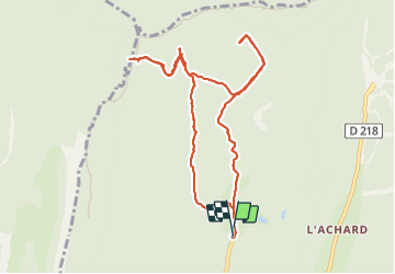

Length
10.3 km

Max alt
1534 m

Uphill gradient
382 m
Km-Effort
15.3 km

Min alt
1294 m

Downhill gradient
382 m
Boucle
Yes
Creation date :
2023-09-08 08:21:27.511
Updated on :
2023-09-22 14:47:09.089
6h19
Difficulty : Medium

FREE GPS app for hiking
 SityTrail
IGN / Geographical institutes
SityTrail Plus
The world is yours!
About
Trail Walking of 10.3 km to be discovered at Auvergne-Rhône-Alpes, Isère, Autrans-Méaudre en Vercors. This trail is proposed by goizet.
Positioning
Country:
France
Region :
Auvergne-Rhône-Alpes
Department/Province :
Isère
Municipality :
Autrans-Méaudre en Vercors
Location:
Autrans
Start:(Dec)
Start:(UTM)
700991 ; 5009779 (31T) N.
Comments